Saturday, October 11, 2014

Backpacking to French Island

A night in the French Island

On a cold October morning, we left home to catch the 6.42 train to Flinders street. It was still dark and very chilly, but we were so looking forward to this day to do our first backpack camping. We have done a numerous car camping in the wilderness, but leaving on foot was new to us. 

After a 40 minute train ride, we changed to a Frankston line for another one hours journey. We had breakfast while on the train and got off at Frankston to catch the v-line to Stony point jetty. As we caught earliest possible trains, we didn't have to worry about missing this train. After about 20 minutes we reached the Stony point which is the end of the line. 

Stony point
I read on the web that we can purchase ferry tickets from a small cafe by the station, so we went ahead and bought two return tickets each costing $ 24. One can buy them on board ferry as well, but we had plenty of time so yeah, why not sort it out.

Small cafe that sells ferry tickets
 After purchasing tickets we found toilets and then freshened ourselves before walking down the jetty.


It was beautiful in the morning out there and despite the cold wind, we walked further down and watched birds and other boats until the ferry arrived. 

It was a long wait as we had arrived way early but it was far better that missing the ferry and having to wait another 2 hours. Finally, around 10 in the morning, we boarded the ferry, stored our packs away and went up to get seated. 

We caught a seal in action eating his breakfast of a big fish. That was a quick ride of a little more than fifteen minutes before we could clearly see the Island jetty.

Tankerton Jetty
We got off at the Tankerton and walked along the path leading to the visitor center. We were stunned by the sight of a long fleet of rusted vehicles along the visitor center. At the center, you can hire either wheels or a bicycle or get on a bus that would take you sight seeing around the Island. 


None of the above options were for us as we were backpacking so we got the direction for the General store which is the only store on the island, and started on foot. We saw a group of elderly people getting on to the one and only bus for a tour. 


The bus itself looked like it has time traveled from back in 70's. Everything on this island had this strange vibe that it looked the whole place is locked in a time capsule. 

It was a long walk of about 5 km to the Store. We felt like we had been walking forever. The road was endless and the area deserted except for a few people passing us on bicycles. We were carrying heavy backpacks and it wasn't easy to enjoy the walk. But the sights were pretty and we stopped at few places to eat our sandwiches. 


Endless road

We passed a few meadows, swamps and farm lands. But they were very different to what you'd find on the main land. It wasn't surprising that not many people live there, because the place is left out and never gotten enough attention from anyone. There were no much buildings or whatsoever except a few houses and a fire station and a community hall. All in all, the island is pretty intact.
Abandoned machines


There were no marked roads, except for just two sign pots at two junctions and we almost thought we got lost. When we finally saw the stores few hundred meters away, it was the best thing.

Surprisingly, the store was in a very good condition and it even had few motels for people to stay.
We went in mainly to get a map and to get the directions. The shop keeper was very helpful. She explained the routes on the map and pointed out few places to visit. 

The store had a small restaurant, essentials item to sell and some local wines and ice cream with wired flavors. We bought two cones and a bottle of wine (only thing we didn't bring).

The farm house on the island is the popular destination of most visitors. Our campsite was on the left corner of the island. We decided to skip visiting places, as it's gonna take a lot of time on foot, with packs. 


This thing called 'pinnacle' was one thing we wanted to see, which is a structure where you can climb up to get a nice birds eye view of the island. So we got the direction and headed to pinnacle. Our plan afterwards, was to cut through the swamps to the campsite, instead of taking the road back.


So we started the long walk again and the further we got the lonelier it got. No sign of civilization. It was wonderful and it felt like we were the only souls on earth.


We were looking for any sigh of a pinnacle but couldn't find anything. Further down, at a fork junction, we met a couple who were returning from the pinnacle, the only humans we saw on that road. Then we started ahead, but after about half an hour, there was still no sign of pinnacle. 


It was decided to walk anyway, cos there wasn't much options left. Then we came to a management track soon after and we were still confused.


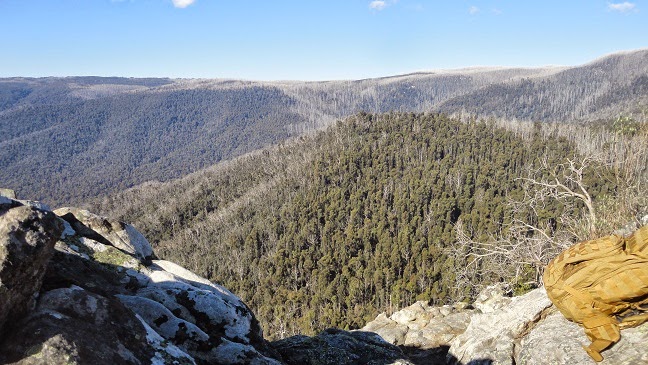
We stopped and tried to see our gps location to no avail. All we could see was an arrow on an empty patch (Island). As we looked around, suddenly, we saw a strange thing popping out of the trees.

The pinnacle

That was an odd structure, we ignored it and decided to walk down to the camp site. We knew we missed the pinnacle somewhere up there. But later we learnt the strange structure is the Pinnacle after all. We had clearly missed it.

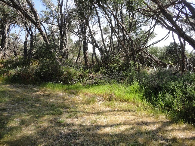
Then came the hardest and most dreaded part of the journey. We followed the track in to the wilderness filled with bushes and swamps. At some places, it was hard to find the actual track, and sometimes we followed tire marks. 


There was nothing to see except for the dry plants and the endless sky. Oh but we saw a few Echidnas trying to run away from us.

A shy Echidna
We kept walking without any direction or sign. At one point I thought we got lost and wanted to turn back and go to the main road. But my partner convinced me somehow and we continued on. It felt like an eternity. 

In the middle of nowhere
 Only clue we had was the blue arrow on the Google apps. So we could know whether we were heading west or not. As long as we are nearing the cost line, we should be fine. It was already afternoon and we had no idea how far were we from the campsite. Next obstacle was a huge swamp. Unfortunately we were not wearing out hiking boots, just the runners and crossing these swamps were a major obstacle. There was no way we could get to the other side without getting muddy and wet. I so wanted to turn back and return to road. But my partner was adamant that we do this somehow and he started cutting thought the bushes. And I followed. We had to clear our way around the swamp. Ya to much relief,  we were finally on the other side and it wasn't that difficult, needed a bit of courage.

Dirty swamp
Crossing the swamp, lifted our spirits up that helped us keep walking despite of no sign. And finally the track started to get shape and we were in a clearing with a wooden fence and what was that!! An Orange arrow. We are saved.


The rest was easy. Not physically, but mentally. Knowing the path was taking you somewhere was a big relief. The scenery started changing and it got prettier.


There were clear signs that we were nearing cost line. The track was covered in white sand and the arrow on the Google map was on the verge of  the island coastal line. We entered the Coastal road soon after that and saw the arrow towards the campsite.


 After a brisk walk among the thicket, we were at the beautiful camp site.

Lovely camp site
It looked like we were the only people there and so yea, it was like we had the entire Island for ourselves that night. Without much delay we pitched the tent, so it gave us time to enjoy the beach before sun set.


It was the loveliest camp site I have ever stayed. The sound of the ocean, cool breeze, shady trees and flowers all over, couldn't have imagined that. Who ever who had named this Fair Heaven, was absolutely correct.

As soon as we pitched the tent, we headed to the beach just on the other side of the site. It was so pretty and not a single soul except for sea gulls and black swans.


Main land in the horizon
This sight is all worth of that long hard walk and crossing swamps. I was swearing on the way, that I'm gonna lie down and not get up until dinner once in the camp site. But all of a sudden, we weren't tired at all. It was still around 5 in the evening and we decided to have a tea by the beach.

Tea in the making

black swans

just before sun set
It was awesome having tea while enjoying the lovely sun set. After the tea, it was time for a lazy stroll along the beach which is one of our favorite things. I always adored, walking the sandy stretches talking, joking,laughing reminiscing. For a few minutes, you forget the whole world.

Sting ray carcass
I suppose we walked for more than an hour and returned to the tent on time to cook dinner.


Dinner 
Dinner was two instant meal packs heated, that we had never tried before. They tasted divine. The wine was pretty good and we were glad we picked the bottle. We never expected that to be a romantic getaway, but at the end, that was what it ended up being.

After a nice dinner, we cleaned the plates, and took the mats down to the beach. With a rest of the wine,a cookie plate and the magical night, it was dreamy.


Pretty colors
We spent few hours chitchatting on the beach, in the pitch dark, under the starry sky, until it was time for a good sleep.

Lights on the main land

I would say, we slept tight that night, and woke up to a beautiful morning. The first thing we heard was the noice of the swans. We slowly walked down to the beach and couldn't believe what we were seeing. There were black swans all over the sea and they were very close to the shore. We stayed there watching that for a long time.


Morning
After washing up and a hot cup of tea it was time again for another stroll along the beach. It was nicer in the morning, but the tides took all the sea water away and it was a long sandy stretch before long. We returned back to the site to have breakfast and get ready to catch the 12 o' clock ferry.

Breakfast
It was indeed hard to leave that place. After packing up everything, we took a last look at the beach and started walking down the Coastal road, this time, no swamps. The scenery along the road was very pretty. There were a few beautiful and magnificent farm houses or bungalows, green meadows, cattle, ducks and a lot of pretty wild flowers.


As there were plenty of time to catch the ferry, we walked up to the General store and bought ice cream and walked leisurely towards the Tankerton jetty.


We had a snack at the jetty and walked around until the ferry arrived.

Ferry arriving
It was sad leaving the Island and looking at each other,we knew we would definitely be coming back for more. 

Saturday, October 4, 2014

Brisbane Ranges Anakie Gorge to Steiglitz

Brisbane Ranges Anakie Gorge to Steiglitz

This was another group hike and we started without really knowing what to expect from this hike but for the sake of being close to nature and to get away from the busy lives. As usual, we had bit of trouble finding the exact meeting point as these remote places are never easy to locate on Google map, let along GPS. Nevertheless, we manged to meet the group on time near the Old court house at Steiglitz.

The drive was very pretty with farmlands and endless plains, but overall it looked like the place hadn't seen much rain lately. So we expected this walk of 17 Km would be tiring in the sun and made sure we carried a lot of water.

We started on a narrow walking track in a long line. Met a few lizards, on the way and I guess we freaked them out more than they us. Someone identified them as blue tongue lizards but well, it wasn't easy spotting their tongue in such a sudden encounter. We strolled between bushes and trees and the scenery looked the same for the most part.


After about an hour or two, we reached the lower stony creek reservoir and the damn which was very massive.

 
 We had a sneak peek in to the whole in the damn which had a mechanism to control the gates. It looked pretty rustic and looked like abandoned. 


All were very eager to see whats on the other side of the damn and so we climbed easily on to the damn wall and entered through a broken fens. The scenery wasn't the best I've seen but of course it was pretty with the waters and the nice breeze. It was the perfect place for a morning snack.


We spent a considerable time there chit chatting and observing the beauty around before descending back on to our walking track. As we continue to walk, we could see the reservoir and the damn from a distance in a different angle. 


The further we walked, the more prettier the reservoir got.


The rest of the hike got a bit tiring as we had to walk uphill for a few hundred meters. It started to get very dry and the skin felt burning despite the cool breeze. 

Hills
  
After the climb we entered a flat terrain which was even more drier but it had flowers all over the place. There were small puddles here and there with little water.


After another hours walk, we reached the Old Mill camp ground, where we had planned to eat our lunch. The camp ground was for overnight hikers and it had toilets and water. We had lunch and rested a while before picking up our hike to complete the circuit.


The rest was all about climbing and hopping and cutting through bushes. It was a fun terrain, with lots of diverse tracks to follow.


After struggling through the dry bushes, we were graced by a lush greenery all of a sudden. It was lovely to see some fresh grass after a long hike in the dried out bushes.


And here we saw some tracks of abandoned mines but they looked like rabbit holes so were not very picturesque or prominent. The greenery was a sign we are reaching some place and before long we were in the border of a huge farm land. 


We walked passing a few more properties and were nearing the end. But not so fast, there was another steep slope to tackle before the finish line.


This was extremely steep that we could almost kiss the ground (not really) and it was good exercise to those lazy calves. Just as we reached the top, we could see the rear of Old court house,our starting point. 
a close by pond
court house
We had managed to complete the circuit before noon and it was time to thank the organizer and say good buys before parting to head home.


Sunday, September 7, 2014

Southern Peninsula walk to Cape Schanck

This 15 Km walk towards  Bushrangers Bay wild beach and of course the views at Cape Schanck Lighthouse has got to be one of the best scenic routes in Victoria. Because of it's popularity, we decided to give it a go. So joined by a set of very enthusiastic hikers from our hiking group, we started the hike from Baldrys Crossing picnic area as planned. Since this wasn't a circuit walk, we had to do a car shuffle. So seven cars went off to the light house car park and the drives returned in one car so that once we end up at the destination, we will all have rides back.

We set off around 10.30 in the morning and the weather was beautiful. We entered the forest which was covered by shady trees and a thick undergrowth of ferns.

View along the trail
Fern undergrowth

We saw a snake by the side of the walk and it was gone before I even finish zooming my lens out. I bet there were more in those bushes. We didn't get tired as we were chit chatting all the way, one advantage of having a group to walk. There were a few clear areas with just the fern growth, and we could see some wild kangaroos, running away from us to the thickets and then peeping at us from a distance. It was such a difficult thing to capture them, so I gave up the idea and enjoyed the moment.

Through the Ferns

The view was changing quite rapidly from that point onward and we could see the farm lands and meadows thought the clearing.

First glimpse of farms
The farther we go , the prettier the view got. I just couldn't resist but stop at every few steps to admire the nice view.

Cattle

More cattle

It was time to take a break, so we gathered up at one mile stone and had a quick snack before starting back towards the Bushrangers Bay wild beach.

Map showing we were halfway through
Along the walk we had more scenery and more kangaroos in packs galloping away over the hills.


There were a few places with steep steps to climb but as as a whole the terrine was flat and so less tiring. When the bushes cleared away, we could see deep blue stretch of the sea from a distance. That was lovely.
First glimpse of the sea

As we grew nearer, we could hear the sound of the breaking waves and feel the nice sea breeze.

What a beauty

Bushrangers bay beach
Finally we arrived at the beach right on lunch time. There were lots of people enjoying the day. We sat on the rocks in a shade and had our lunch. Few set off to explore a reef close by while others enjoyed each other company while chit chatting. After about an hour of nice rest, we set off for the light house. Time to hit the bushes again.


Natural arches

About an hours walk brought us to a nice look out, where we could see the ocean with a great view and the light house from a distance.


Light house 

Another few more minutes with that nice view and we were there at the light house and that ended our day hike. Everyone seemed to have thoroughly enjoyed the walk and the scenery along the way. 
Path to light house

 Cape Schanck  light house

So we jumped into our cars and drove back to Baldrys Crossing, where everyone said their goodbyes before heading to homes. This place is definitely worth a re-visit due to it's diverse flora and fauna and the breathtaking scenery.

Saturday, August 30, 2014

Cathedral Ranges

This was our first hike with a hiking group in Melbourne and we were exited about making some new friends and the grade 5-6 hike that was ahead of us. We didn't know what to expect and as it was led by the group organizer, we were a bit relaxed than we were on our own. So we drove off to the meeting point in Taggerty, Buxton. The drive was beautiful and we passed many scenic sights and midst plains, villages, farms and occasional clouds.

Thick mist

We reached out meeting point right on time and we took a few minutes to stretch and freshen up and also to get to know each other with a brief introduction. After making sure everyone is packed with essentials, we set off. The path was well formed since it is used as a management track in some periods. We could see the once burn't tree trunks through the green regrowth.

Regrowth

We kept walking, chit chatting and after about an hour, the organizer declared that we had been going the wrong direction. That was funny and we thought that was a nice warm up session after all and started walking back to the starting point. We had missed the sigh to the Messmate track which was partly hidden and not so prominent.


Finally few found it and the track was just a narrow foot path through the jungle and we had to walk in a line one after the other. It was a bit tiring having to walk up hill at a stretch. We took five minutes break after every 10 minutes of walking and after about an hour, we reached to Sugarloaf car park. Everyone was starving by the time and so we decided to have lunch there and stretch ourselves before the climb.

Sugarloaf saddle

We were told the next 20 minutes is going to be bit rough as we will have to do some rock scrambling to reach the peak. We started of another up hill walk and it became harder with every few steps and finally we were facing the rocky wall. It was a bit scary as we didn't have any ropes or other gear to support the climb and it was so steep that looking down gave me goose bumps. But we managed to tackle it one by one and the group helped each other. We met another group climbing down the same rocks half way through and it was quite a challenge to manage to top.

Looking down

As soon as we reached the top, we were stunned by the extraordinary 360 degree view and it is worth all the trouble and risk we took to get there.


We sat on the rocks and enjoyed the view and it simply felt great. From here one can either climb down and take another similar challenge to see the Wells cave or take the Sugarloaf razorback circuit to the ground. We took the second option and we could clearly see the razorback from there.

Razorback
Interesting terrain
It wasn't boring at all as we had to jump, scramble, crawl and even squeeze through the rocky track. Some rocks were slippery and we found occasional wet swamps.

Challenging track
after about another two hours, we were able to arrive at the Farmyard campsite where we stooped for a few minutes to rest and have a snack.

Single tent in Farmyard

It was starting to get cold and we had another 2 hours walk to Cooks mill campsite. So we picked up our phase as we didn't want to walk through the jungle in the night. Climbing down wan't easy, specially in that speed but we reached the Cooks mill campsite in record time.

Kangaroos in Cooks mill

 Everyone was so overjoyed about the day's achievement and we decided to treat ourselves with some dinner on our way back. It was an unforgettable experience and we felt accomplished even with sore limbs.